‘I think London, though charming, a most illogical city. I don’t know its boundaries: you don’t; nobody does…’1
I imagine that most people researching London’s history have probably, at some point, asked the question: what is, or was, London, anyway? The quotation above, taken from an article written by the humorist Stephen Leacock in 1925, points to the difficulty, or even the impossibility, of deciding where the city begins and ends with any degree of certainty. It wasn’t a new problem in the 1920s, and it’s still one faced by town planners and local authorities today.2 As a video posted recently on the Londonist website shows, even knowing whether or not you live in London isn’t always straightforward.
During the first half of the nineteenth century, when London’s population and area was growing rapidly, many people had particular trouble getting to grips with the sheer scale of the new ‘Metropolis’ (a word that was first applied to London in the 1820s). On the whole, the urban historian Patricia L. Garside suggests, ‘it was less a matter of dealing with the consequences and problems of London’s growth than of comprehending its extent and significance’.3 The different bodies that emerged to regulate and govern London came with their own ways of defining the city. The Metropolitan Board of Works (established in 1855) and the Administrative County of London (from 1889) set new administrative boundaries, no longer confined to the ‘Square Mile’ of the old City of London. But, already by the 1880s, statisticians were talking about a much bigger Greater London, equivalent to the Metropolitan Police District, extending 15 miles in all directions from Charing Cross.4 Over the years, improvements in transport links and increased levels of industry on the outskirts of the city meant that London’s suburbs and satellite towns spread even further into the neighbouring counties of Middlesex, Hertfordshire, Essex, Surrey and Kent. On top of these overarching definitions, London was also divided and sub-divided into smaller parishes and boroughs, as well as into less formal neighbourhoods, forming what Roy Porter, in his history of the city, talks about as a complex ‘jigsaw’ of diverse, and sometimes overlapping, local communities.5
All this is to say that setting the boundaries of London for the purposes of research isn’t always an easy task. For this project, I’ve tried to be led by my sources. Much of my information about London’s early cinemas has come from the records of the London County Council (LCC), held at the London Metropolitan Archives. From 1910, the LCC (and specifically its Theatres and Music Halls Committee) was responsible for issuing licences for cinemas in the Administrative County of London, established by the 1888 Local Government Act. This was an area stretching (in meandering lines) north to Hampstead and Clapton, east to Limehouse and Woolwich, south to Tooting and Catford, and west to Putney and Hammersmith. From 1900, it was divided into 28 municipal boroughs (plus the semi-autonomous City of London). In theory, any venue in this Inner London area planning to show films to a public audience more than six times a year needed a cinematograph licence from the LCC to operate. Depending on the number of musicians employed to accompany films, cinemas might also need to apply to the council for music licences. These requirements (and the LCC’s knack for meticulous record-keeping) have left a wealth of paperwork documenting the construction, running and regulation of film venues in Inner London from 1910 onwards. There are also more occasional records of film exhibition going back to the 1890s.6
Using the records of the LCC as my primary material, it would have been possible (and maybe sensible) to stick to mapping those cinemas that opened during the period of silent films in the Administrative County of London only. What pushed me out further, into Greater London and beyond, was my other main sources of information. For the very early period (1909 and earlier), these sources included reports from the Metropolitan Police, whose reach extended well beyond that of the LCC. This explains, for example, why the London’s Silent Cinemas Map includes early venues in Sutton, then part of Surrey, and Barking, then in Essex. The other main sources of information for the later period (1910 onwards) were film trade directories. Publications such as The Bioscope Annual and Trades Directory (published 1910-1915) and the Kinematograph Year Book (published 1914-1970) contain extensive if not always comprehensive lists of film venues, along with the names and addresses of film producers, distributors and suppliers of equipment.7 From the start, directories like these treated London cinemas as a separate category, giving them their own section within longer catalogues of ‘Picture Theatres in Great Britain’.
The special status afforded London’s cinemas in trade directories may have just been an editorial quirk – a way to deal with the growing number of cinemas, not just in the capital, but around the country. It’s not always clear exactly how and why film trade directories decided what was and wasn’t a ‘London’ cinema. Nor is it consistent across the period I looked at (up to 1930). Sometimes, whole districts – especially those on the fringes of the city, like Croydon to the south or Enfield to the north – move out of, or more often into, the London listings. Part of the explanation for this, of course, lies in the changing shape of the city at the start of the twentieth century, and especially in the spread of what Alan Jackson calls ‘semi-detached London’ in the outer suburbs.8 The number of people living in Outer London, outside London County, rose from just over 2 million in 1901 to an estimated 3.4 million by 1928.9 In this sense, the increasingly sprawling remit of the ‘London cinemas’ sections of publications like the Kinematograph Year Book reflected the nature of London as a city in these years. Where they’ve presented themselves to me, I’ve filled in some of the more glaring gaps in the register of film venues provided by early film trade directories (using the evidence of local borough histories, old maps and articles in trade journals). But, overall, it’s these sources that have given this project its geographical scope and shape.
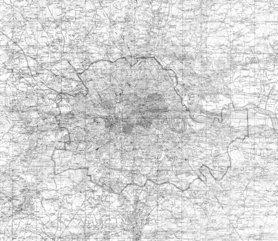
To be clear, then, the geographical area covered by the London’s Silent Cinemas Map is not based on any official administrative boundaries, past or present. Instead, it follows looser definitions of the city, and especially the interpretation of ‘London’ favoured by film trade directories. There are undoubtedly drawbacks to this approach. To begin with, some parts of modern Greater London are not included. I’m certain that there were many cinemas in what are now the outer London boroughs that were not considered to be ‘London cinemas’ before 1930, and so (regrettably) do not appear on this site. The history of film exhibition in the rapidly expanding suburban outskirts of the city and neighbouring Home Counties would certainly merit further study.
At the same time, working with looser definitions of London also has its advantages for a project like this. As I see it, beyond simply being more flexible, one of the main benefits of following a film trade directory understanding of London is that it offers another view of the city. This view isn’t based on political boundaries or physical markers like roads and railways, but on the less visible networks of commercial activity – in this case, the cinema business. Looked at this way, the London’s Silent Cinemas Map shows the extent of the early London cinema business as imagined by some of the people who, for various reasons, kept a particularly close eye on it. It’s possible (although, again, this would require further investigation) that this understanding of London’s limits had a bearing on how local branches of early professional film industry groups (such as the Cinematograph Exhibitors’ Association) were organised, and perhaps on how films circulated in and around the region. For the time being, though, the map offers one more set of historical city boundaries to add to London’s already charmingly illogical geography.
Image: Detail from Kelly’s Map of London and the Suburbs (c. 1920). The thick grey line shows the boundaries of the Administrative County of London.
For more information on the materials involved in mapping London’s cinemas for this site, see the Sources page.
- Stephen Leacock, Journal of the London Society, 8:3 (1922): 5; quoted in Cathy Ross, Twenties London: A City in the Jazz Age (London: Museum of London/Wilson, 2003), p. 115. ↩
- Matthew Gandy, ‘Where Does the City End?’, Architectural Design, 82:1 (2012), 128-33. ↩
- Patricia L. Garside, ‘West End, East End: London, 1890-1940’, in Anthony Sutcliffe (ed.), Metropolis 1840-1940 (London: Mansell, 1984), pp. 221-58: p. 226 (my emphasis). ↩
- Richard Dennis, ‘Modern London’, in Martin Daunton (ed.), The Cambridge Urban History of Britain (Cambridge: Cambridge University Press, 2001), pp. 95-132: p. 96. ↩
- Roy Porter, London: A Social History (London: Penguin, 2000), p. 13. ↩
- The film historian Tony Fletcher has sifted through much of this material. Some of his findings are published in: ‘The London County Council and the Cinematograph, 1896-1900’, Living Pictures, 1:2 (2001), 69-83; ‘A Tapestry of Celluloid, 1900-1906’, Early Popular Visual Culture, 4:2 (2006), 175-221; and A Kinematographic Journey through London 1907-8 (London: Local History Publications, 2013). See also the work of Jon Burrows, especially: ‘Penny Pleasures: Film Exhibition in London during the Nickelodeon Era, 1906-1914’, Film History, 16:1 (2004), 60-91; and ‘Penny Pleasures II: Indecency, Anarchy and Junk Film in London’s “Nickelodeons”’, Film History, 16:2 (2004), 172-97. ↩
- A digitised version of the 1914 Kinematograph Year Book is available to view on the British Film Institute website. Several other editions are also available via the Media History Digital Library. ↩
- Alan A. Jackson, Semi-Detached London: Suburban Development, Life and Transport, 1900-1939, second edition (Didcot: Wild Swan, 1991). ↩
- H. Llewellyn Smith (ed.), New Survey of London Life and Labour: Volume I: Forty Years of Change (London: King, 1930), pp. 72-3. ↩
")